The company offers key solutions for early detection and data-driven policymaking against and disaster -related emergencies in Latin America.
Ricardo Guerra, Regional Sales Director LATAM, comments on their services.

How does Planet utilize its satellite technology to effectively monitor and address the global impacts of disaster-related emergencies?
Planet leverages its satellite technology by deploying a diverse fleet of over 200 satellites, such as the Dove, SkySat, Pelican and Tanager constellations. These satellites capture high-frequency, high-resolution imagery of the Earth's landmass on a near- daily basis, providing near-real-time data on environmental changes.
This continuous data stream facilitates the detection of subtle changes in ecosystems, including deforestation, glacier melt, and urban expansion, among other related changes. By making this data accessible, Planet supports researchers, governments, and organizations in formulating informed strategies to help mitigate and respond to disasters at a global scale.
How can the real-time data and imagery provided by Planet assist governments and organizations in responding more effectively to floods and wildfires?
Planet facilitates early detection and monitoring. Planet's satellites provide frequent updates that allow for early detection of potential disasters. For example, identifying dry, high-risk areas prone to wildfires or monitoring rising water levels that could lead to flooding.
Also, Planet enables rapid response and assessment. During an emergency, high-resolution imagery helps in assessing the extent of damage quickly, identifying affected areas, and prioritizing response efforts. This can significantly reduce the time required to mobilize resources and aid.
Additionally, Planet contributes to situational awareness. Continuous monitoring allows for real-time updates on the progression of an event, such as the spread of a wildfire or the inundation pattern of a flood, helping authorities to make informed decisions on evacuation orders and resource allocation.
In addition, Planet facilitates post-event analysis. After the emergency, Planet's imagery aids in damage assessment, recovery planning, and the implementation of measures to prevent future incidents.
How do Planet solutions help in tracking and combating deforestation efforts?,
Planet solutions allow early detection, monitoring compliance, data-driven policy making, and carbon stock assessment.
Planet's daily imagery enables the early detection of illegal logging activities and deforestation, allowing authorities to take swift action. Also, governments and organizations can monitor adherence to environmental regulations and conservation efforts by observing changes in forest cover over time. Accurate, up-to-date information on forest conditions –provided by Planet solutions– helps policymakers create and enforce effective environmental protection policies. Finally, forests act as carbon sinks, and monitoring their health is vital for understanding carbon stock and flux and necessary mitigation efforts. .
In the broader context, combating deforestation helps to reduce greenhouse gas emissions, preserve biodiversity, and maintain ecosystem services that are critical for long-term resiliency and growth.
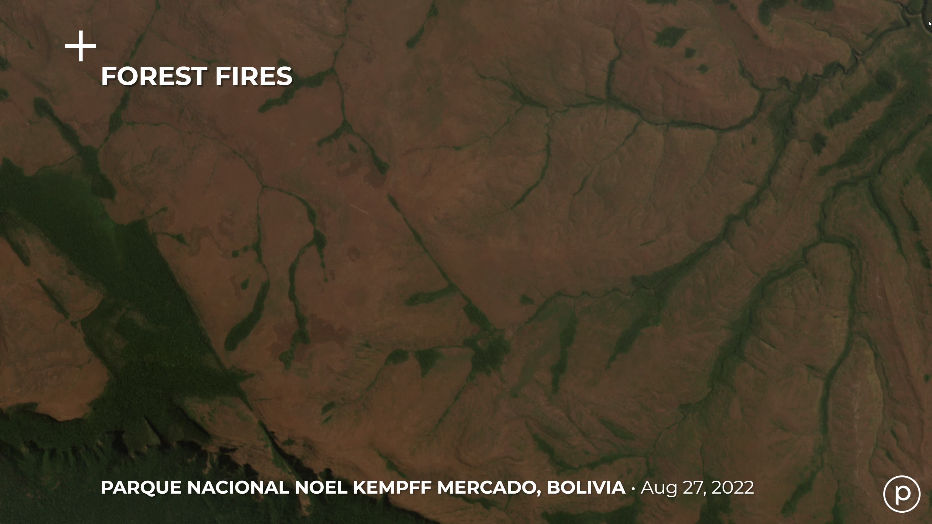
In 2024, forest fires destroyed more than 79 million hectares in South America. Chile experienced the deadliest fire in the world in a century; Bolivia lost 15% of its land; and Brazil reported the highest number of fires seen in the 21st century.
According to the Inter-American Development Bank (IDB), climate-related natural disasters in Latin America have tripled over the past 50 years, leading to progressively worse impacts on morbidity, mortality, ecosystems, and economies.
What partnerships or collaborations has Planet formed in LATAM to enhance its efforts in providing actionable insights for disaster response and management?
In LATAM, Planet has formed several key partnerships and collaborations to enhance its efforts in providing actionable insights for disaster response and management. Some notable collaborations are with Procalculo (Colombia) and SCCON (Brazil) which leverage Planet's satellite data to deliver innovative solutions.
Procalculo uses Planet’s high-resolution imagery to monitor forest cover changes in Colombia. This collaboration helps in detecting illegal logging activities, assessing forest health, and ensuring compliance with regulations. Also, Procalculo collaborates with the Colombian Geographic Institute (IGAC) to support the Observatorio de la Tierra (OTT). This project includes developing a virtual platform for spatial information, enabling the monitoring and tracking of changes in Colombian territory using remote sensing data. This platform aids in various applications such as urban planning, regulations, and resource management.
SCCON utilizes Planet’s real-time imagery to assist governments and organizations in responding to natural disasters. For instance, during the recent tragedy in Rio Grande do Sul (Brazil), where heavy rains caused severe flooding, SCCON provided critical data for emergency response, helping to map affected areas and coordinate relief efforts. Additionally, SCCON supports the Brazilian Federal Police through the Rede Mais program by using Planet’s data to combat deforestation, illegal mining, and other illicit activities. This monitoring helps protect natural resources and ensure enforcement of regulations and protections that are in place. .
How do these collaborations amplify the impact of Planet technology?
They provide local expertise and ensure that the satellite data is interpreted correctly and used effectively in regional contexts. They also bring actionable insights tailored to specific needs; and enhance the scalability of Planet's solutions across different sectors and regions in LATAM, leading to broader adoption and driving greater impact on meeting initiatives and goals..
By working with Procalculo and SCCON, Planet improves its ability to deliver meaningful, data-driven solutions that address critical environmental challenges in LATAM. These partnerships exemplify how combining advanced satellite technology with local expertise can drive significant progress in and disaster response and management.
About Planet Labs PBC
Planet is a leading provider of global, daily satellite imagery and geospatial solutions. Planet is driven by a mission to image the world every day, and make change visible, accessible and actionable. Founded in 2010 by three NASA scientists, Planet designs, builds, and operates the largest Earth observation fleet of imaging satellites. Planet provides mission-critical data, advanced insights, and software solutions to over 1,000 customers, comprising the world’s leading agriculture, forestry, intelligence, education and finance companies and government agencies, enabling users to simply and effectively derive unique value from satellite imagery. Planet is a public benefit corporation listed on the New York Stock Exchange as PL. To learn more visit www.planet.com, contact the LATAM Team at [email protected] and follow us on X (formerly Twitter) or tune in to HBO's ‘Wild Wild Space’.